
This guide covers England and Wales. Scotland uses Registers of Scotland and Northern Ireland has its own land registry (NI Direct guide), so if your property is there you’ll need their services instead.
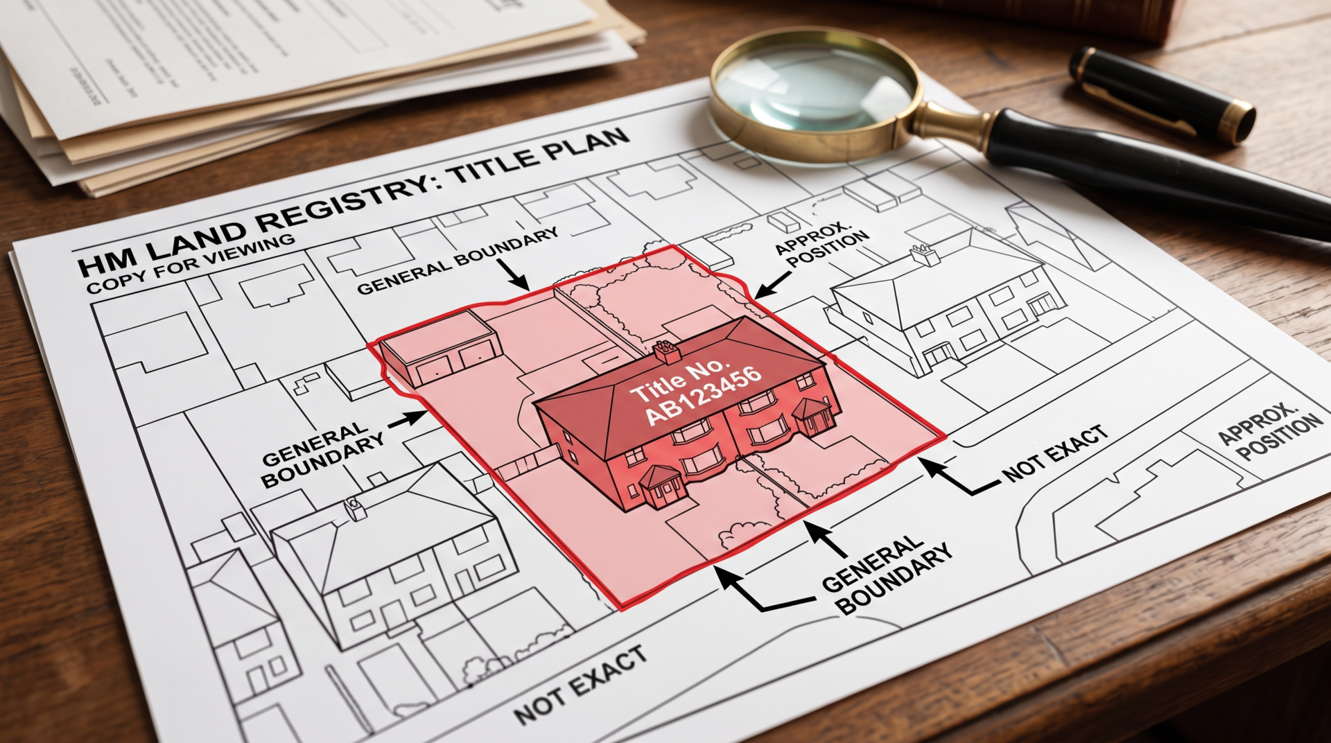
Quick answer. A Land Registry map is usually the HM Land Registry title plan for registered land in England and Wales. It shows the property’s general boundaries as red edging on an Ordnance Survey map. The red edging is approximate, not an exact legal line, so don’t take measurements from the plan to locate a boundary on the ground.
How can you view a Land Registry map online?
Start with GOV.UK’s Search for land and property information service. You’ll need to sign in or create an account, and a debit or credit card if you want to download documents. Search by address, postcode or title number. The service offers other search options too.
The document most people mean by “Land Registry map” is the title plan. It costs £7 to download, the same as the title register. The free property summary won’t give you a boundary map. It shows the address, tenure and whether restrictive covenants or easements exist, and you need the register to see the details.
One catch: downloaded copies can’t be used as proof of ownership. For that you order an official copy, which is posted to you and costs £11 per document.
| Property summary | Title register | Title plan | |
| What you get | Address, description, tenure, and whether covenants or easements exist | Owner, last sale price, mortgage, and covenant and easement details | The property’s location and general boundaries, shown as red edging |
| Cost | Free | £7 | £7 |
| Good for | Checking a property is registered and how it is held | Seeing who owns it and what rights and restrictions apply | Seeing the registered extent of the land |
Fees checked on GOV.UK on 28 September 2026.
Land with no postal address
A field, a garage block or a strip of land behind other properties may not come up cleanly from a postcode search. Try a nearby address or the street name, then read the title plan to see whether it covers the parcel you mean. Once you have the title number, use it for every later look-up.
Who owns the land? Land ownership maps and data
There is no single free map of UK land ownership. What you can find depends on the land and the owner.
• Registered land appears in the GOV.UK search, and the title register names the owner.
• Unregistered land returns nothing, which doesn’t mean nobody owns it. HM Land Registry said in 2019 that 14% of freehold land in England and Wales was still unregistered.
• Company-owned property is easier. HM Land Registry publishes datasets of UK companies and overseas companies that own property. Most of the data is free, though you may need an account and a licence agreement. Private individuals aren’t included.
• Developers and data users can use the Use land and property data service, which is built for bulk analysis.
HM Land Registry’s guide to getting information about property and land explains what each route returns.
How do you find your property boundaries in the UK?
Most people assume the red line answers this. It only partly does. The rest comes from paperwork and from the ground itself.
A five-step check
1. Read the title register and title plan. Note the title number and any references to deeds or plans.
2. Look for deeds marked “copy filed”. If you don’t hold copies, you may be able to get them with form OC2. Even then the plans may be unclear.
3. Check documents from your solicitor. The purchase file may hold a plan or boundary notes the register lacks.
4. Talk to your neighbour before changing anything. They may hold the same paperwork, or know who put a fence up and when.
5. Get advice if you need the exact line. That means a legal professional or a chartered surveyor.
Legal boundary vs physical boundary
A legal boundary is the invisible line between two pieces of land. A physical boundary is something you can see, such as a fence, wall, hedge or ditch. It may follow the legal line, sit to one side of it, or drift over time. Fences get replaced a foot over, or put up by a previous owner who never looked at the plans.
So “my fence is 400 mm inside the red line” isn’t, by itself, evidence of anything.
T marks and H marks
Some deed plans show a “T” against a boundary. It often indicates who is responsible for maintaining that fence, wall or hedge, usually the owner on the side where the T sits. Two Ts back to back form an “H”, which may mean both neighbours share responsibility. Read the wording in the deed too, because the marks alone aren’t conclusive. The HMLR guide on how to read a title plan covers what appears on a plan.
Boundaries next to roads
If your property borders a public highway, the title plan won’t show the exact line between private land and highway land. Land that looks like yours may still be part of the highway, so check before making changes near a road, pavement, verge or access route.
How accurate is a Land Registry boundary map?
Not accurate enough to measure from. A title plan shows general boundaries, the approximate position of a boundary rather than its exact line. It is drawn on Ordnance Survey mapping, which has limits of scale and accuracy, so HM Land Registry says not to rely on measurements taken from a title plan to locate the legal boundary.
The rule behind this is section 60 of the Land Registration Act 2002. It says a registered boundary is a general boundary unless shown as determined, and that a general boundary does not fix the exact line. HM Land Registry repeats the advice in its boundaries and boundary disputes guide, published on 24 September 2026.
Why scaling off the plan goes wrong
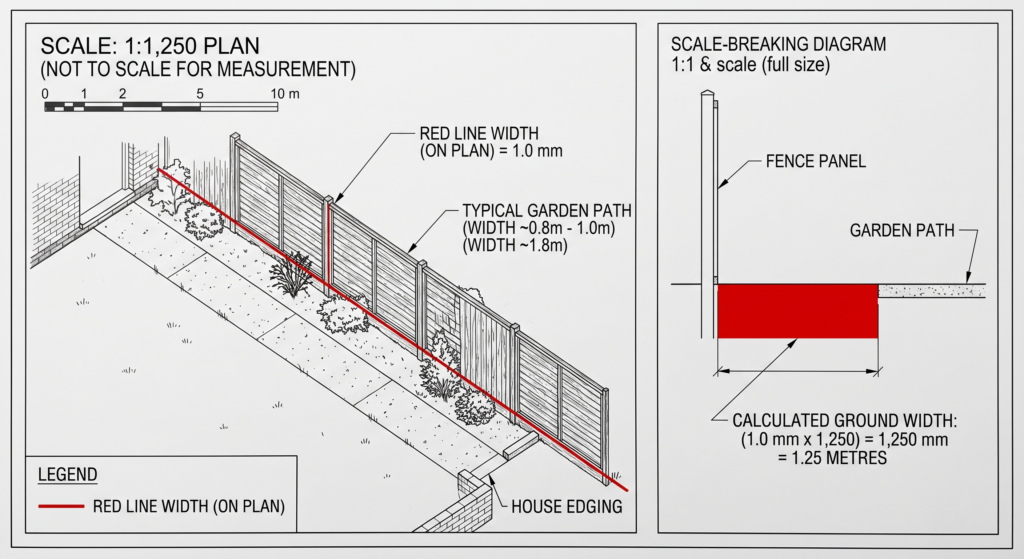
Your title plan states its scale. At 1:1,250, one millimetre on paper is 1.25 m on the ground. At 1:2,500 it is 2.5 m. A red line half a millimetre thick, drawn at 1:1,250, already covers about 60 cm of ground. Measure from that and you can be out by more than a fence panel.
Leasehold flats
If you own a flat, the red edging on your title plan may outline the whole building rather than your flat. That happens because the plans are drawn on small-scale Ordnance Survey maps, which can’t show every detail. It is why many flat owners feel the “map” tells them nothing. The document that defines your flat is the lease plan, read alongside the register and the lease. Our guide to title plan vs lease plan explains the difference.
Can the red line be moved?
Sometimes. If you can show clear evidence that the red edging is in the wrong place, HM Land Registry may move it to a more accurate position. It will still only show a general boundary. If you want to know what the edging is meant to do, see our explainer on red line plans.
A determined boundary goes further and fixes the exact line on the register. Fewer than 1% of registers have one, usually because applying can be expensive, and the plan will almost always need to be produced by a chartered land surveyor. HM Land Registry can’t decide, mediate or resolve a boundary dispute between neighbours.
When do you need a measured survey or professional plan?
When someone has to rely on exact dimensions. A title plan tells you what land is registered and roughly where it sits. It can’t tell a builder where to place a footing.
| Document | What it shows | Use it for | Don’t use it for |
| Title plan | Registered land, with general boundaries as red edging | Checking what is registered and roughly where | Measuring, setting out, or fixing an exact line |
| Lease plan | The demise (the flat or unit let), defined precisely | Leases and deeds of variation | Settling where a neighbour’s boundary runs |
| Measured survey | Dimensions taken on site and drawn to a stated scale | Design work, setting out, drawings | Legal advice on who owns what |
Architects, builders and structural engineers
Design work and setting out need dimensions from a measured site survey, not from scaling a title plan. This matters most near a boundary, where a few hundred millimetres can put a wall on a neighbour’s land. Building on or close to the line may also engage the Party Wall etc. Act 1996, and HM Land Registry can’t advise on it, so take advice from a solicitor, conveyancer or surveyor.
Solicitors
Solicitors meet the title plan’s limits in lease and boundary work.
• Lease plans must define the demise precisely, which a title plan doesn’t do. HM Land Registry’s Practice Guide 40 covers what it expects from plans.
• Deeds of variation that change what is demised need a new plan. See our note on a deed of variation plan.
• Boundary agreements let neighbours fix a line by agreement. GOV.UK explains how to make a boundary agreement.
• Determined boundaries need a precise plan, almost always from a chartered land surveyor.
If neighbours already disagree, the RICS boundary disputes guide is a sensible read.
Our take: what a Land Registry copy can and can’t do for a lease plan
We see this often. A client applies to extend a lease and finds the plan on the Land Registry’s copy is unusable. It may be mostly blank, faded, or missing a scale. The lease itself is fine, but a new deed can’t rely on a plan that isn’t drawn to a stated scale.
A recent example, anonymised: a leasehold garage in a residential close in London. The owners were extending the garage lease and had only the Land Registry’s copy of the original lease, where the plan was largely illegible. The layout itself was clear enough, but it had no scale. Under current Land Registry requirements that meant it couldn’t be reused as it stood.
The brief was specific: re-create the plan to scale and keep the original colouring. That mattered because the rights of way in the lease are described by reference to those colours. If the colours changed, the rights would no longer line up with the plan, and the extended lease could describe different rights from the original.
We measured the garage and the access route on site and redrew the demise to a stated scale, following the RICS Code of Measuring Practice and HM Land Registry Practice Guide 40. We kept the original colour scheme, so the rights of way carry through unchanged.
Our view: a Land Registry copy is the right place to see what was granted, but it is a record of the original deed, not a working document. If the plan lacks a scale, is unclear, or doesn’t match what is on site, don’t try to copy it by eye. A plan redrawn to scale, with the original colouring and references preserved, keeps the extended lease consistent with the one it builds on.
Need a lease plan or measured survey? Our Land Registry compliant plans and lease plan site survey are built for exactly this. See our lease plan examples, or ask for a free quote.
FAQ
Is the Land Registry map free?
You can search on GOV.UK and download a free property summary for registered property. The title plan, which shows the general boundaries, costs £7 to download, and so does the title register. Downloaded copies can’t be used as proof of ownership; an official copy, sent by post, costs £11 per document. Fees checked on GOV.UK on 28 September 2026.
Does the red line show the exact legal boundary?
No. In almost all cases the red edging shows the general boundary only, which is the approximate position of the boundary and not its exact line. HM Land Registry advises against relying on measurements taken from a title plan to work out where the legal boundary lies on the ground.
Can I find who owns land with no address?
If the land is registered, you can search on GOV.UK and use the title register, which names the owner, for a £7 fee. Unregistered land returns no result, although someone still owns it. HM Land Registry’s company ownership datasets are free with an account, but they don’t cover private individuals.
Does the map show who owns a fence?
Usually not. There is no rule that the fence on the left or right belongs to a particular property, and the side the posts are on isn’t a reliable guide. Check the title register, deeds marked “copy filed” and any T marks on deed plans, which often show maintenance responsibility but aren’t conclusive.
When do I need a measured survey?
You need one when exact dimensions matter, such as design work, setting out building works, lease plans, or a determined boundary application. A title plan shows registered land and general boundaries, so it isn’t suitable for taking measurements. A measured survey takes dimensions on site and draws them to a stated scale.

